Bokoro Airport
Location: Bokoro, Mai-Ndombe
Status: Active with regular flights
ICAO Code: none
IATA Code: none
Coordinates: -2.884714°, 18.352761°
Bokoro is a town along the Lukenie River, approximately 30 kilometers east of Kutu, where the Lukenie merges into the Fimi River. It originated as a mission settlement, with historical photographs from the place dating back as early as 1915.
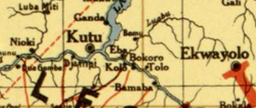
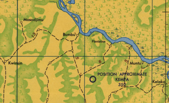
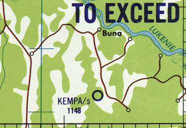
Despite its long-standing existence, Bokoro does not appear on some more recent maps. The 1966 Joint Operations Graphics published by the U.S. Defense Mapping Agency refers to the town as “Bumbu,” while the 1996 U.S. Tactical Pilotage Chart labels it as “Buna.” These inconsistencies already indicate that something went wrong in the geographic documentation of Bokoro.
Historical Background
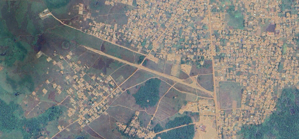
Bokoro Airport remains largely undocumented. Just eight kilometers south of Bokoro, another airstrip, Kempa Airport (FZBG), once existed and was clearly marked on both the 1966 Joint Operations Graphics and the 1996 U.S. Tactical Pilotage Chart. Low-resolution satellite imagery from 1984 shows a well-defined runway at Kempa, while the area that now hosts Bokoro Airport appears only as a faint line. Over the following years, Kempa Airport’s runway gradually fades, indicating it was abandoned, while Bokoro Airport’s runway becomes more pronounced, suggesting that for some reason, Bokoro Airport replaced Kempa as the primary airstrip for the area.
Current status (as of 2025)
Bokoro Airport is active and maintained, though it does not host scheduled flights. The airline KinAvia lists Bokoro Airport for regular charter flights.
Bikoro and Bokoro – The Result of a Spelling Error?
The official ICAO location indicators list contains an airport called Bikoro Airport (FZBC). This airport allegedly serves the town of Bikoro, located at the shore of Lake Tumba. However, old maps and even local sources confirm that there has never been an airport at Bikoro - the town was instead served by the airfield of Yembe-Moke (FZEM). More curiously, the third letter of the ICAO Code, “B,” suggests it belongs to the Bandundu region, not Équateur province, where Bikoro is located. This strongly indicates that the ICAO Code FZBC was never actually intended for the town of Bikoro.
One possibility is that FZBC was originally assigned to Bokoro Airport, but due to a spelling error or misinterpretation, the name “Bokoro” was mistaken for “Bikoro.” While this may sound strange, such name inconsistencies are actually quite common in the Democratic Republic of the Congo, where multiple airports have had slight variations or outright spelling errors in the official ICAO database over the years.
What makes this theory slightly less credible however is the fact that Kempa Airport (FZBG) was located just eight kilometers from Bokoro - and it appears unusual for two official airports to exist (or have existed) so close to each other. It is possible that Kempa was originally the designated airfield for the region and that Bokoro only became relevant after Kempa was abandoned.
What remains certain is that FZBC is misplaced in the official ICAO register, but the question remains: Was it actually meant for Bokoro, or was it assigned to yet another location that has since been forgotten? If you have any additional information about Bikoro, Bokoro, or their airports, feel free to reach out!