Sanda-Samuna Airport
Location: Sanda-Samuna, Kongo Central
Status: Redeveloped
ICAO Code: none
IATA Code: none
Coordinates (unverified): -5.651934°, 13.443264°
Little information is available about the area surrounding Sanda-Samuna Airport. In this region, National Road 1 takes a northern detour between Boma and Matadi, avoiding the challenging terrain near the Congo River. Several large villages and smaller settlements are scattered along this route.
Approximately 20 kilometers north of Matadi, a series of villages includes the name “Sanda” — notably Sanda-Samuna, Sanda-Kizulu, and Nsanda-Kitata. No detailed online records exist about these villages, and satellite imagery suggests that they remain basic, with no significant infrastructure. The only notable building in the area, located at -5.622558°, 13.445861°, was constructed only in 2018, long after Sanda-Samuna Airport had already been abandoned.
Historical Background
No information is available regarding the establishment of Sanda-Samuna Airport, and due to the lack of documented history on the surrounding villages, its original purpose remains unknown.
The collection of colonial-era maps available online does not cover this area, meaning that the airport’s first known depiction appears in the 1967 Joint Operations Graphics, published by the U.S. Defense Mapping Agency. Interestingly, this map marks two airfields in close proximity to the Sanda villages:
- Mvula-Sanda Airport (FZAY)
- Sanda-Samuna Airport
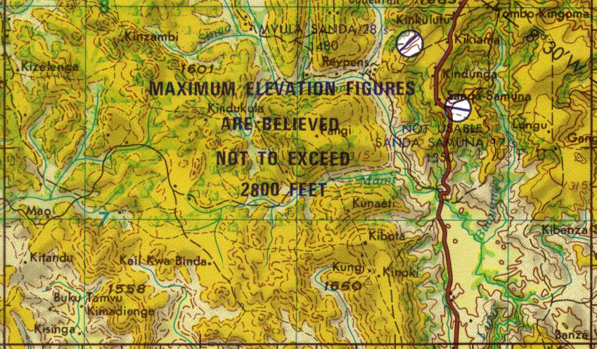
By 1996, the U.S. Tactical Pilotage Chart shows that only Mvula-Sanda Airport remained, suggesting that Sanda-Samuna Airport was abandoned earlier.
Current Status (as of 2025)
The 1960s U.S. aeronautical charts use multiple methods to indicate airports. Some airfields are marked with a small circle symbol accompanied by the note “approximate position,” while others are depicted with a round shape and a runway heading, indicating that their exact location was known. Sanda-Samuna Airport falls into the latter category, suggesting that its position was precisely recorded on the map.
Available satellite imagery of the location indicated for Sanda-Samuna Airport dates back to 2011 (high resolution) and 1984 (low resolution). In both cases, no visible traces of the airfield can be seen, and even the alignment of a former runway is undetectable.
The site of Sanda-Samuna Airport, as shown on the 1967 aeronautical chart, is now part of the village of Sanda-Samuna, developed with scattered small houses and footpaths. This suggests that the airport was abandoned long ago, and its former location has been completely redeveloped over time.