Kimpoko Airport (FZAE)
Location: Kimpoko, Kinshasa
Status: Redeveloped
ICAO Code: FZAE
IATA Code: none
Coordinates (verified): -4.214337, 15.558997
Kimpoko was once a small village located approximately 30 kilometers northeast of Kinshasa. Positioned between N’Djili International Airport and Maluku Airport, the area remained largely undeveloped until the mid-1960s.
During this period, President Mobutu Sese Seko selected a location just south of Kimpoko for an ambitious and highly prestigious political retreat and luxury resort. This area was named N’Sele, although its proximity to Kimpoko also led to it being commonly referred to as Kimpoko-N’Sele.
The development of N’Sele included monumental construction projects, featuring a presidential palace, extensive accommodations, monuments, swimming pools, and a botanical garden. The area became the headquarters of the MPR (Mouvement Populaire de la Révolution), Mobutu’s single-party system that ruled Zaire until the 1990s. In 1967, the “Manifeste de la N’Sele” was drafted here, laying out the ideological foundation of the MPR.
Throughout Mobutu’s rule, N’Sele remained a blend of political seminar venue and luxurious resort, frequented by political elites and foreign dignitaries. However, the retreat’s fate changed dramatically in the early 1990s when Kinshasa faced political unrest and riots. During the subsequent Congo Wars, N’Sele was extensively looted and destroyed, leaving it in ruins. In the years that followed, the once-glorious retreat was left abandoned, gradually reclaimed by vegetation.

Historical Background
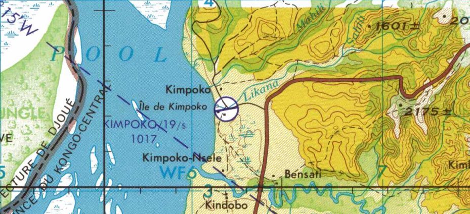
Little information exists regarding the establishment of Kimpoko Airport. However, it is officially listed in the ICAO database as FZAE. In this case, too, the letter E suggests an early assignment of the ICAO code, indicating that the airport predates Mobutu’s N’Sele project. The 1966 aeronautical Joint Operations Graphics map, published by the U.S. Defense Mapping Agency, marks Kimpoko Airport near the main road leading to Kimpoko. Based on this, two possible scenarios exist:
-
The airport predates the N’Sele project. Little is documented about Kimpoko’s role during the colonial era, but some records suggest missionary activities by Scheut missionaries, and the Compagnie du Congo pour le Commerce et l’Industrie (C.C.C.I.) is mentioned in relation to a land request at Kimpoko. However, it remains unclear whether C.C.C.I. actually owned the land. Kimpoko Airport could have been established to support these activities.
-
The airport was constructed in parallel with the N’Sele resort. In this scenario, its primary function would have been to fly in government officials, architects, and high-profile guests during the construction of the prestigious retreat. However, if this is the case, then the ICAO code FZAE must have been reassigned to Kimpoko Airport, meaning it was previously assigned to another airport in the A region.
Only an official ICAO airport list or a version of ICAO Doc 7910 from around 1960 could confirm which scenario is correct. So far, these documents have not been obtained. If you have access to either, please reach out!
Current Status (as of 2025)
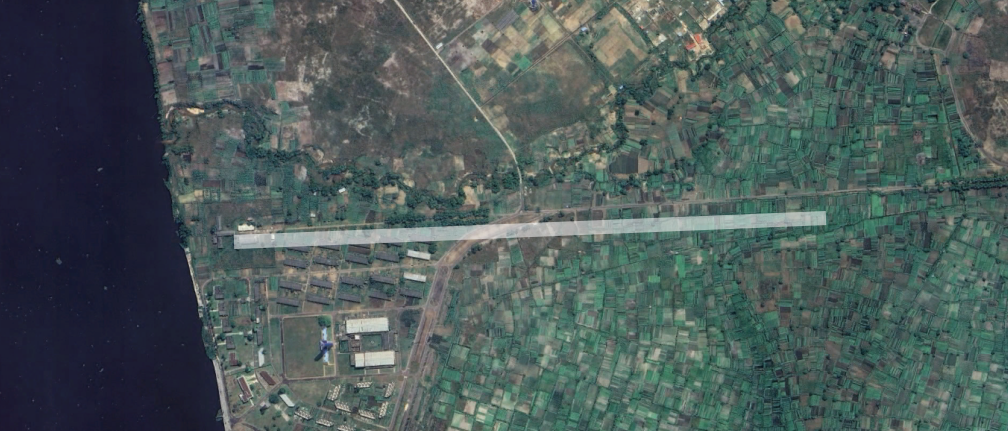
By 1996, Kimpoko Airport was no longer depicted on the U.S. Tactical Pilotage Chart, suggesting that it had ceased to exist by then. Satellite imagery of the location indicated on the 1966 map shows that the area was later redeveloped with additional accommodations for the N’Sele resort — likely during the 1970s when the site was still actively in use. Today, no trace of Kimpoko Airport remains.
In recent years, the Congolese government has taken actions to restore N’sele and its facilities. Gradually, they have again been established as a tourist destination, but the restoration works are far from complete.