Inga Airport (old)
Location: Inga, Kongo Central
Status: Redeveloped
ICAO Code: none
IATA Code: none
Coordinates: -5.517293°, 13.582857°
Wikipedia features a comprehensive article on the Inga Dams, providing detailed information on their history, current state, and future developments. The following summary is based on that article.
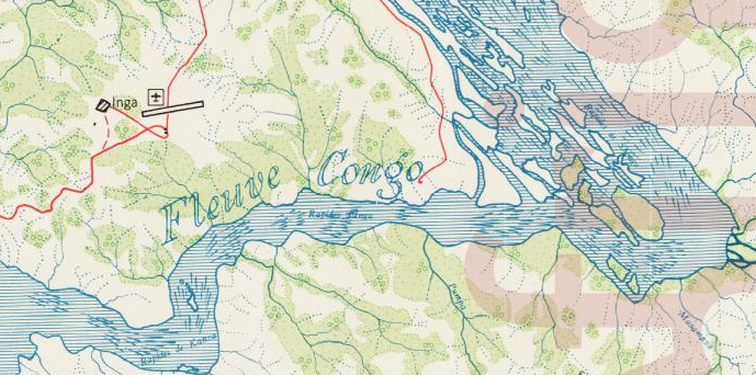
The Inga Dams are a series of hydroelectric facilities located on the Congo River, approximately 220 kilometers southwest of Kinshasa. They harness the immense power of the Inga Falls, where the river drops 96 meters with an average discharge of 42,000 cubic meters per second.
The first installation, Inga I**, was completed in 1972, with a capacity of 351 megawatts (MW). It was followed by Inga II in 1982, capable of producing up to 1,424 MW. Despite their potential, both dams have faced persistent maintenance issues, aging infrastructure, and unreliable electricity generation. While rehabilitation efforts continue, much of their capacity remains underutilized due to financial and operational challenges.
Looking forward, the Grand Inga Project envisions an expansion that could generate between 40 and 70 gigawatts (GW), making it the largest hydroelectric power facility in the world. However, progress has been slow, with repeated delays due to funding difficulties, political instability, and logistical hurdles. In early 2025, the Chinese state-owned Three Gorges Corporation withdrew from the initiative, adding further uncertainty to its future.
Historical Background
The earliest known cartographic depiction of an airfield at Inga appears on a 1955 map (featuring 1953 data) published by the Institut Géographique du Congo Belge. The presence of an airstrip at such an early date is notable, as while ideas for a dam at Inga existed as early as the 1920s, no detailed development plans were made until 1957.
The initial purpose of the airfield at Inga remains unclear. It may have been constructed to support early exploratory missions for the dam project, but it is also possible that it served as an access point for the Inga Falls, which could have attracted scientific and touristic interest at the time.
By 1967, the Joint Operations Graphics published by the U.S. Defense Mapping Agency still depicted Inga Airport at the location shown on the 1955 map. However, this edition of the map introduced an unexpected detail — it also showed a second airfield at Inga, labeled “Inga old”, with the note “not usable”.
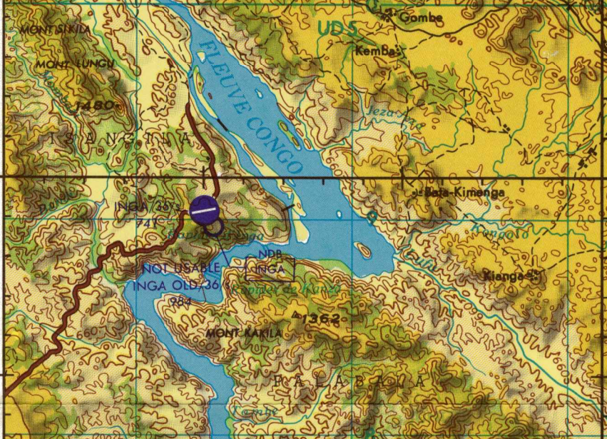
For documentation purposes, this additional airfield is referred to as Inga Airport (old) II. It was located just southeast of the existing Inga Airport (old). This is anomalous, as the 1955 map already depicted what should have been the “new” airport at Inga at that time. Since no other sources confirm the existence of Inga Airport (old) II, a separate article has not been created for it.
At some point between 1965 and 1984, a new airport was constructed at Inga, southwest of the initial airfield. This new facility, now known as Inga Airport (FZAN), replaced the original Inga Airport.
Current Status (as of 2025)
Following the completion of Inga Airport (FZAN), the site of the old airfield was redeveloped. Today, no trace of Inga Airport (old) remains.