Kinshasa Binza Airport (FZAK)
Location: Binza, Kinshasa
Status: Unknown, does not exist
ICAO Code: FZAK
IATA Code: none
Coordinates: Unknown, possibly near -4.3670°, 15.2500°
Binza was originally a small village located near Léopoldville, the colonial capital that later became Kinshasa. Following World War II, Binza was developed into an upper-class neighborhood, primarily inhabited by white settlers. After the Congo gained independence in 1960, the district retained its elite status, but its residents changed: the newly emerging Congolese political elite moved into the luxurious homes once occupied by Belgian officials.
The name Binza became widely known due to the groupe de Binza, a powerful political faction led by General Joseph-Désiré Mobutu in the early years following independence. Many of its members lived in the prestigious Binza neighborhood, using it as a political and social base. The group wielded considerable influence until Mobutu’s coup d’état in 1965, after which it ceased to exist.
As Kinshasa expanded in the 1960s, Binza was gradually absorbed into the urban fabric. Today, the former suburb is fully integrated into the city and could almost be considered a central district due to Kinshasa’s rapid growth.
Historical Background
Very little is known about Kinshasa Binza Airport (FZAK). No official ICAO records or versions of ICAO Doc 7910 listing the airport could be found, raising doubts about whether it ever existed as an operational airfield.
The only references to FZAK appear in two online sources. The website PilotNav lists FZAK and even provides coordinates (-4.3670, 15.2500), placing it just southeast of the former Binza village site. Additionally, an obscure text file from the U.S. Department of Agriculture mentions the code FZAK in connection with Binza. While no concrete evidence confirms that the airport was ever functional, these references suggest that it may have been listed in older versions of ICAO Doc 7910, though no such records are available online for verification.
One notable feature of Binza is its large meteorological station, which has existed since the colonial era and maintains a connection to aviation through weather data collection.
Current Status (as of 2025)
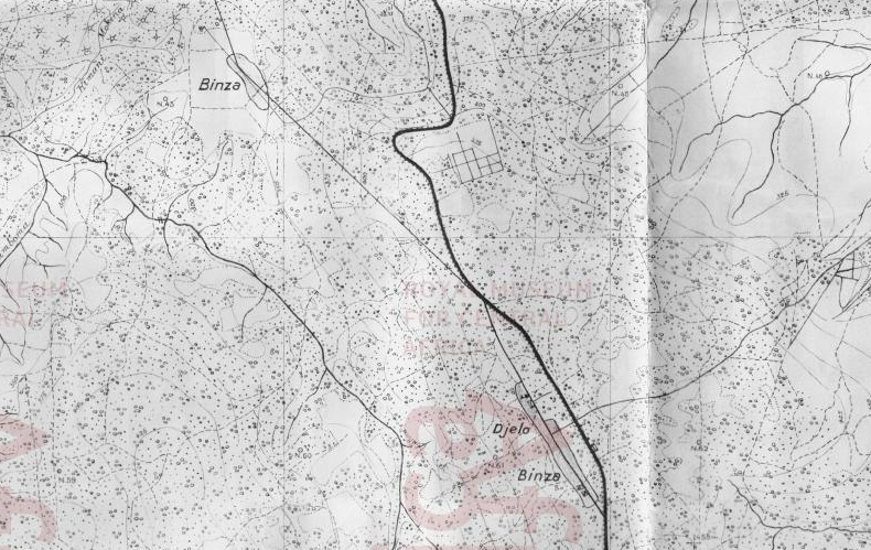
No historical maps or aeronautical charts have been found depicting an airport at Binza. This includes a colonial-era map from 1955 and various aviation charts from the 1960s, all of which show no sign of an airstrip in the area.
The absence of any mapped evidence makes the existence of Binza Airport highly unlikely. The most plausible explanation is that, at some point, the meteorological station in Binza was assigned an ICAO code (FZAK) due to its aviation-related function. However, this designation appears to have been revoked shortly after its assignment, as FZAK does not appear in any publicly available versions of ICAO Doc 7910.